
Province of New Jersey, Divided into East And West, Commonly Called
Item #80050
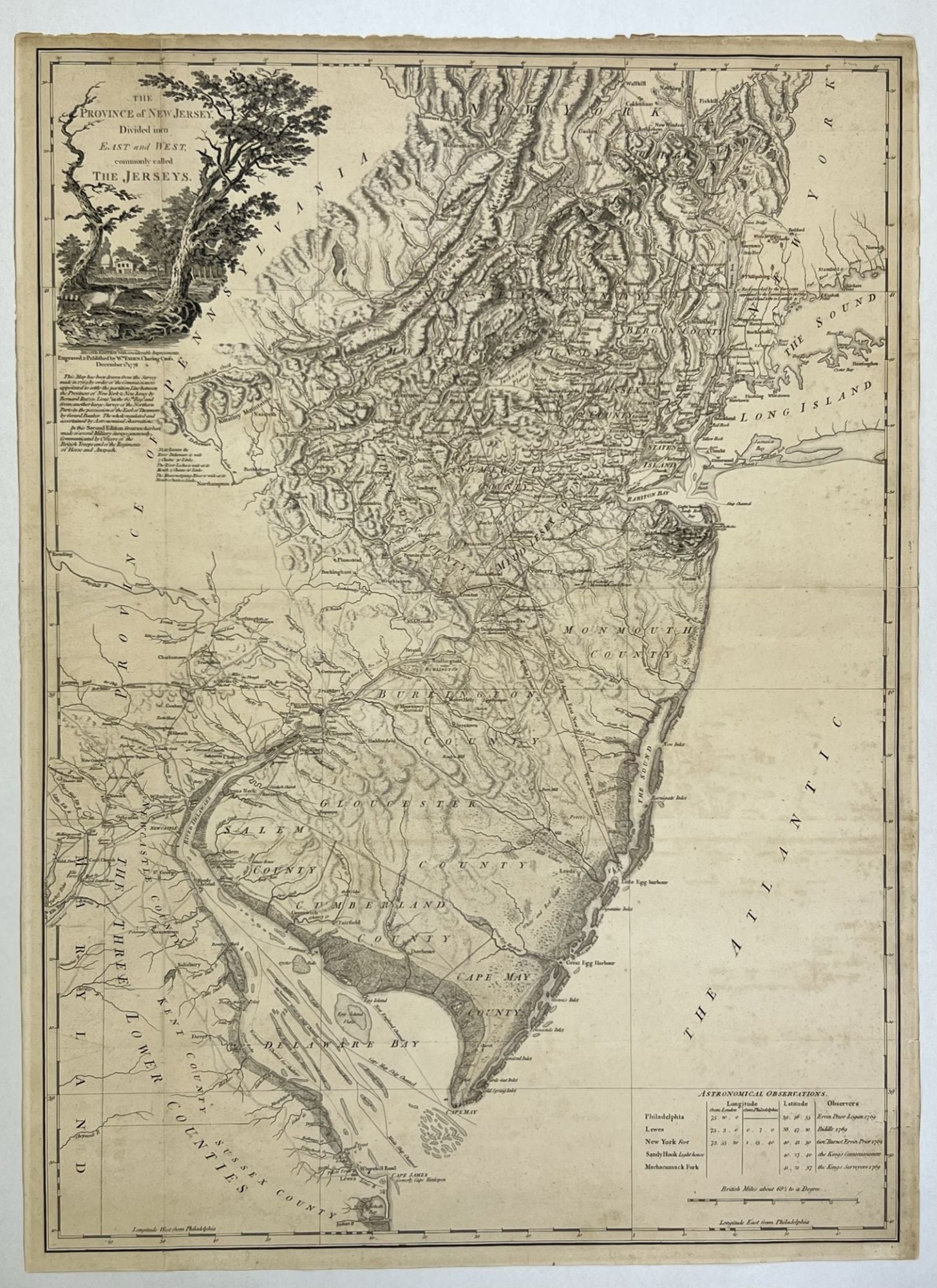
FADEN, William, and RATZER, Bernard. The Province of New Jersey, Divided into East And West, Commonly Called Called The Jerseys. London: Wm. Faden, December 1, 1778. 2nd ed. with Considerable Improvements. Copper-engraved map on two joined sheets, 32 x 24 inches in total, with original outline color. Guthorn, British Maps of the American Revolution, p.39. Degrees of Latitude 47. Schwartz & Ehrenberg, p.193. Snyder, The Mapping of New Jersey, pp.57-59. This elegant composition depicts New Jersey in finely engraved detail at a large scale of seven miles to an inch. The map was the grandest representation of the state made up to that time, taking in the entire breadth of the state, as well as the Hudson Valley, most of Long Island, eastern Pennsylvania, and all of Delaware Bay. It captures the state's rich topography, including the Jersey Highlands and the Palisades in the north and the broad Pine Barrens and coastal marshes in the south. The county divisions, major roads and towns are all carefully depicted, indicating that New Jersey was, by the standards of the time, heavily populated, having over 120,000 inhabitants. "In this Second Edition great use has been made of several Military Surveys generously Communicated by Officers of the British Troops and of the Regiments of Hesse and Anspach." Faden based his rendering of the state largely on the manuscript works of Bernard Ratzer, a British military surveyor most famous for his map of New York City. Ratzer's rendezvous with New Jersey cartography stemmed from the resolution of the bitter boundary dispute between that state and New York that had raged for over a century. In 1764, George III charged Samuel Holland and Willian De Brahm with settling the boundary, and their demarcation was finally surveyed by Ratzer in 1769. Ratzer's line is noted on the map as "The boundary settled by commissioners in 1769." Two of Ratzer's New Jersey manuscripts, one dealing with the boundary question, and another featuring Monmouth and Ocean Counties are today preserved in the Faden Collection at the Library of Congress. Faden supplemented Ratzer's work with surveys of the northern part of the state made by Gerard Bancker. Curiously, it seems that Bancker's work found its way to Faden, by way of John Murray, the Earl of Dunmore, the former governor of Virginia, who was given a draft.
Price: $12,500.00